ANDORRA
Principality of Andorra
Principat d'Andorra
Motto: "Virtus Unita Fortior" (Latin)
"Strength United is Stronger"
Anthem: El Gran Carlemany, Mon Pare (Catalan)
The Great Charlemagne, my Fath
Location of Andorra (green)in Europe (dark grey) — [Legend]
Capital
(and largest city) Andorra la Vella
42°30′N 1°31′E
For 715 years, from 1278 to 1993, Andorrans lived under a unique co-principality, ruled by French and Spanish leaders (from 1607 onward, the French chief of state and the Spanish bishop of Seu d'Urgell). In 1993, this feudal system was modified with the titular heads of state retained, but the government transformed into a parliamentary democracy. For decades Andorra enjoyed its status as a small refuge of fiscal and banking freedom and benefitted from Spanish and French tourists attracted to the country's duty-free shopping. The situation has changed in recent years as Andorra started to tax foreign investment and other sectors. Tourism accounts for over 80% of Andorra's gross domestic product.
The year 1993, Andorra lived a great moment, approving the "Constitution", and the entry in the United Nations, and all their entities. The representative of the Principate, raises the catalan language to the highest European institutions, using this language (official language of Andorra) in his speech at the U. N.
Nowadays, Andorra, under the government of the "Molt Honorable Sr. Marc Forné i Molné", consolidates as a great touristic and commercial center, as well as in the practice of winter and mountain sports, as well as an incomparable place to enjoy some days with its thermoludic complex "Caldea".
Topographic map of Andorra.
Total Area: 468 sq km (100% land).
Total Land Boundaries: 120.3 km.
Total Coastline: 0 km (landlocked).
Climate: Temperate; snowy, cold winters and warm, dry summers.
Terrain: Rugged mountains dissected by narrow valleys.
Elevation Extremes: Riu Runer 840 m (lowest point).
Pic de Coma Pedrosa 2,946 m (highest point).
Natural Resources: Hydropower, mineral water, timber, iron ore, lead.
Land Use: Arable land ---- 2.13%. Permanent Crops ---- 0.00%. Other ---- 97.87%.
Natural Hazards: Avalanches.
Geography Note: Landlocked; straddles a number of important crossroads in The Pyrenees.
Map of Andorra with its seven parrishes labeled.
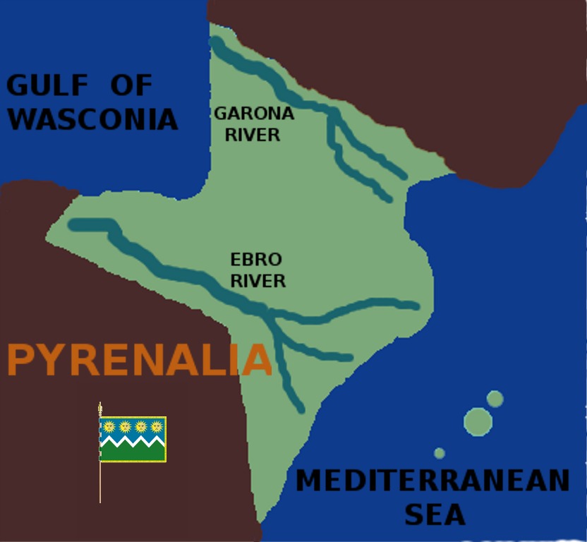
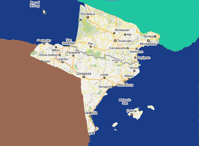
PYRENEAN ISTHMUS AND PERIPHERIA In this blog we are going to try to bring you any kind of useful information that has happened and is happening all along The Pyrenean Isthmus and peripheria, from ocean to ocean and from river to river. We hope you find it useful and enjoyable. And at the same time, we invite you to send us any information related to the subject in any language to be translated into English, by our staff. The address to contact us is: subolospirineos@gmail.com
PYRENEAN ISTHMUS AND PERIPHERIA
2011-10-21
2011-10-19
8576 TOWNS MAKE UP THE PYRENEAN ISTHMUS
According to PIF:
THE PYRENEAN ISTHMUS (PI) IS MADE UP OF A TOTAL OF 8576 TOWNS OR CITIES.
ANDORRA (as a country has 51).
By Counties or Cantons:
ALACANT......................................141
ARABA............................................51
ARIÈJA..........................................332
AUDE............................................438
BARCELONA................................312
BIZKAIA........................................111
CANTABRIA..................................102
CASTELLO....................................135
ERAU.............................................343
GARD.............................................353
GERS.............................................463
GIPUZKOA......................................85
GIRONA.........................................221
GIRONDA......................................542
ILLES BALEARS..............................67
LA RIOJA........................................174
LANAS............................................331
LLEIDA...........................................231
NAFARROA GARAIA........................57
NAUTA GARONA...........................589
NAUTS PIRENEUS........................474
OLT E GARONA.............................319
PIRENEUS-ATLANTICS.................547
PIRENEUS-ORIENTALS.................226
SARAGOSSA..................................292
SORIA............................................183
TARN..............................................324
TARN E GARONA..........................195
TARRAGONA.................................183
TERUEL.........................................236
TREBINYO.........................................1
UESCA...........................................202
VALENCIA......................................265
JAMES I OF ARAGON
James I the Conqueror (Catalan: Jaume el Conqueridor, Aragonese: Chaime lo Conqueridor, Spanish: Jaime el Conquistador, Occitan: Jacme lo Conquistaire; was born in Montpehlier on 2 February 1208 – and died in Valencia on 27 July 1276) was the King of Aragon, Count of Barcelona, and Lord of Montpellier from 1213 to 1276. His long reign saw the expansion of the Crown of Aragon on all sides: into Valencia to the south, Languedoc to the north, and the Balearic Islands to the east. By a treaty with Louis IX of France, he wrested the county of Barcelona from nominal French suzerainty and integrated it into his crown. His part in the Reconquista was similar in Mediterranean Spain to that of his contemporary Ferdinand III of Castile in Andalusia.
As a legislator and organiser, he occupies a high place among the Spanish kings. James compiled the Llibre del Consulat de Mar, which governed maritime trade and helped establish Catalan-Aragonese supremacy in the western Mediterranean. He was an important figure in the development of Catalan, sponsoring Catalan literature and writing a quasi-autobiographical chronicle of his reign: the Llibre dels fets.
As a legislator and organiser, he occupies a high place among the Spanish kings. James compiled the Llibre del Consulat de Mar, which governed maritime trade and helped establish Catalan-Aragonese supremacy in the western Mediterranean. He was an important figure in the development of Catalan, sponsoring Catalan literature and writing a quasi-autobiographical chronicle of his reign: the Llibre dels fets.
2011-10-18
PIF
http://www.dailymotion.com/video/xjz61j_pyrineo_news
http://www.midipyrenees.fr/-Actualite-Les-Pyrenees-effets-illimites
http://www.midipyrenees.fr/-Actualite-Les-Pyrenees-effets-illimites
Subscribe to:
Posts (Atom)